Peyrepertuse Castle
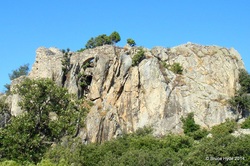
Peyrepertuse castle, above, is located on a limestone ridge at an altitude of about 800 m. towering over scrubland and vineyards. It is a strategic position which enabled one at the same time to see far into the valleys that circle it, to control the mountain passes, or to send communication signals to the château de Quéribus a little further south.
The site was occupied during Roman times from the beginning of the 1st century B.C., as recent archaeological excavations have shown. The first historical references to the castle appeared in 806. It was then Catalan and was called Perapertusès. It belonged to the Count of Besalú, a small city situated in Catalonia between Figueres and Olot according to a text from 1020.
The castle was decommissioned as a border point with the Treaty of the Pyrenees in 1659 having lost its strategic interest. Although the citadel was a lot less valuable after the annexation of Roussillon in 1658, a small garrison commanded by a junior officer was maintained until the French Revolution, during which it was abandoned. Sold as a National Property in 1820, its ruins remain today.
Castell d'Ultrera
Ultrera name comes from the Latin Castrum Vulturarium, that is to say, the castle of the vulture . This name reflects the difficult access of site. It was reported that "Ultrére was a real den of vultures literally and figuratively."
The castle stands on a barren rocky outcrop high above the village of Sorède watching all the plain of Roussillon. It is part of a series of fortifications (the watchtower La Massana and the ancient castle of Montbram, located above the village of Lavail) designed to monitor and defend a natural passage between Roussillon and Catalonia . This highly strategic point was fortified by the Romans, probably at the time of the conquest of the Iberian Peninsula.
There is very little of the Roman castle remaining, the majority of the building dating from the time of the Visigoth (VI - VII centuries). Nearby is the "Four Solaire" which served in one of the first experiments of its kind made in the world. It is the result of the work of Antonio Manoel Gomes nicknamed "Padre Himalaya" because of his large size.He was a physicist, monk and Portuguese. Today all that remains of this site are a few concrete slabs and rusty metal parts.